

ADMS · GPS Mapping (General) module
GPS field mapping and zone soil testing, from your own laptop.
GPS Mapping is the foundation every ADMS module runs on. Connect your GPS, take your laptop or tablet PC to the field, and collect boundaries, lines, and points while the cursor tracks exactly where you are.
What it does
Your maps, in the field, with you on them.
GPS Mapping turns a laptop or tablet PC into a data collection unit. Define zones, plan sampling, and see your position on every map you own.
Map fields where they are
Collect points, lines, and polygons as you drive. Build field boundaries and mark the areas you want to define, right from the field.
Sample the right spot
The cursor tracks your location on your zone maps, so you pull zone soil samples, ditch, and spray weed patches exactly where you planned.
Start with what you own
Import the SHP, MID/MIF, and TAB data you already have. TIGER data, NAIP imagery, and soils data come with the software.
In ADMS
What GPS Mapping looks like.
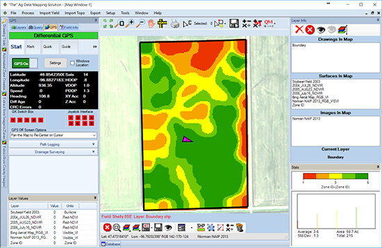
Real screens from ADMS. Turn GPS on, load your field, and your position shows up on every layer you have.
Your live position
Latitude, longitude, speed, and heading on screen, with the cursor tracking you across the field and its zones.
County data, loaded
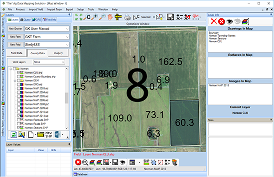
TIGER data, NAIP imagery, and soils data are included, with instructions for downloading future data.
Know where you are
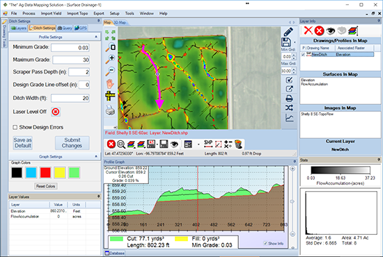
View your field location as you do your ditching. Shown here with the Topography & Drainage module's ditch tools.
Why GK
GK pioneered RTK watershed modeling and in-cab drainage displays, with patented technology behind SD Drain machine control.
How it works
From the office to the field and back.
Load your fields
Import boundaries in SHP, MID/MIF, or TAB format, or draw polygons, lines, and points in the office over your background imagery.
Connect your GPS
Connect your GPS to your laptop or tablet PC and turn GPS Mapping on.
Head to the field
The cursor tracks your location on your maps while you collect points, lines, and polygons.
Put it to work
Pull zone soil samples, ditch, and spray weed patches, then add modules as your mapping grows.
Pricing
GPS Mapping is the General module, the base every ADMS module is built on. Start here, then add Topography/Watershed or Variable Rate Create when you need them. Buy both add-ons together and the second is half price.
Questions
Common questions.
It is the base of ADMS. GPS Mapping connects your GPS to your computer so you can take a laptop or tablet PC to the field, collect data, and see your location on your maps.
Yes. Topography/Drainage, Imagery/Yield/Variable Rate, and the consultant packages all run on top of the GPS Mapping base.
Yes. Define your zones and plan sampling in the office, then take your laptop to the field. The cursor tracks your location as you collect zone soil samples.
Yes. Import existing data collected from other sources in SHP, MID/MIF, or TAB format, or create polygons, lines, and points yourself.
With any GK software purchase, GK makes sure you have TIGER data, NAIP (FSA National Ag Imagery Program) images, soils data, and instructions for downloading future data.
ADMS runs on Windows, versions 7 through 11, on your own laptop or tablet PC. The mapping happens on your machine, not in a browser.
Contact
Get in touch with GK.
Tell us a little about your operation and what you are trying to solve. A real person in Halstad reads every message and follows up within a few hours.