

Ag Data Mapping Solution
Turn your field data into variable rate maps and drainage plans.
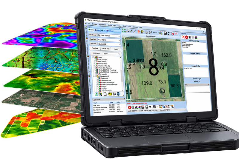
ADMS is GK's desktop software for agronomy and drainage. Build it up module by module, so every acre gets the right rate and every field drains the way you want.
35+ years in precision ag | Runs across the US & Canada | In-Cab and Windows desktop
What ADMS is
One program for the whole field, crop and water management.
ADMS is built as task-focused modules, so you add exactly the capability your operation needs and skip the rest. Click through what each one does across the field.
Build your fields and collect data in the cab
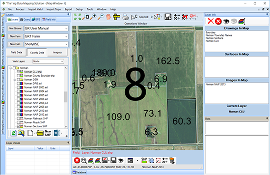
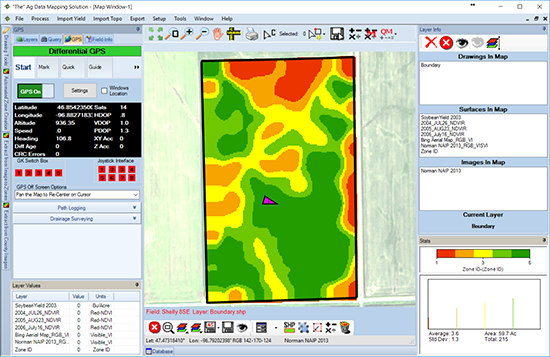
GPS Mapping is where every ADMS setup begins. It turns a laptop or tablet into a live data collector, so you build the fields and gather the data the rest of ADMS works from.
- Create field boundaries, lines, and points
- Zone sample, ditch, or spray with the cursor tracking your location
- Lay out grid points for soil sampling
- Convert shapefiles to raster and back
From imagery and data to management zones
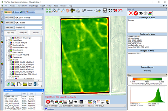
Bring in the imagery and field data you already have, clean it up, and split fields into the zones your sampling and prescriptions are built on.
- Import geo-referenced imagery (.jpg, .grd, .bmp, .tif, .ecw, .sid)
- Surface, filter, and zone images for sampling
- Clean yield data and merge multiple Veris depths
- Build zone and grid maps from imagery, yield, soils, and EC
Application maps your controller can run
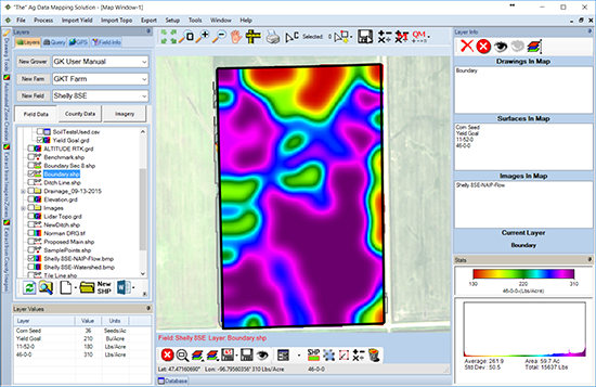
Turn your zones and data into variable rate application maps, from a simple few-zone map to 200 and beyond, ready to send straight to the field.
- Create soil result maps and VR application maps
- Go from three to five zones up to 200-plus
- Manual rate entry or script-driven prescriptions
- Export to common rate controllers
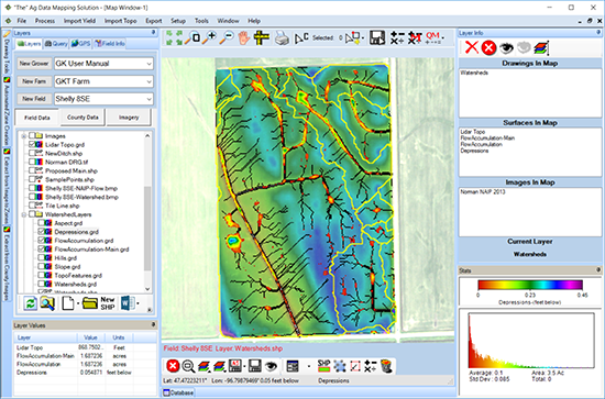
The elevation model behind every drainage decision
Import a single point file and ADMS builds a topography map and a whole series of others, so how water moves across the field stops being a guess.
- Create a DEM from RTK or LiDAR elevation
- Map depressions, hills, slope, aspect, and contours
- Trace flow paths and watershed areas
- Built for drainage planning across the whole field
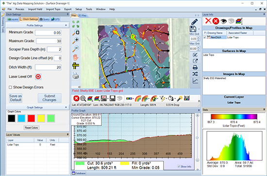
Ditch and tile plans, cut and fill to the inch
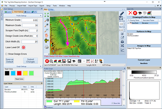
Take the topography map and design a ditching or tile plan, with the soil you will move and the cut and fill worked out in inches before a machine touches the field.
- Plan ditches and design tile layouts
- See side profiles with grade and depth
- Get a visual estimate of cut, fill, and soil moved
- Reshape and re-slope fields with land shaping
From bare elevation to a drainage picture.
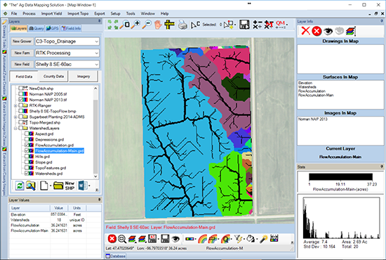
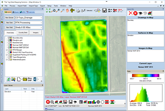
ADMS takes the elevation model of a field and turns it into the map you plan ditch and tile from. Same field, two views.
- Left: the raw elevation surface
- Right: watersheds, flow paths, and depressions
- Plan ditch and tile straight from what you see
↔ Drag the slider to compare
The modules
Build the Ag Data Mapping Solution that fits your operation.
Every ADMS starts with GPS Mapping and expands from there. Add the modules your work calls for, each with a page of its own.
GPS Mapping
Every ADMS starts here. GPS Mapping turns a laptop or tablet into a field collector and builds the boundaries and zones the rest of ADMS is built on. Add modules on top as your operation grows.
- GPS sampling and data collection
- Lay out grid points and field boundaries
- The foundation every module builds on
Add-on modules
Variable Rate Create
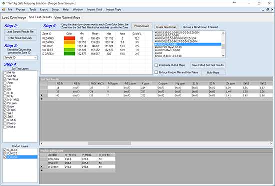
Put the right rate on every acre. Turn imagery, yield, soils, and EC into zones and prescriptions that send inputs where they pay.
- Zone and grid maps for sampling
- Soil result maps and VR prescriptions
- Exports to common rate controllers
Topography/Watershed
See how water moves, then plan to move it. Find the wet spots and lay out ditch and tile with grade, cut, and fill.
- Elevation models, watersheds, contours
- Hills, depressions, slope, and aspect
- Ditch and tile plans with profile and depth
Surface Shaping
Reshape the field so water leaves the way you want, moving the least soil to hit the grade.
- Cut, fill, and balance soil movement
- Machine-ready shaping plans
- Requires Topography/Watershed
FODD, the bridge to your equipment
Field Operations Data Drivers write your ADMS maps to the rate controllers and equipment you already run.
For consultants and dealers
Consultant Package
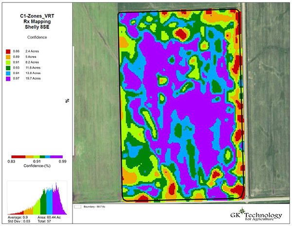
Map a lot of acres, fast. GK's data library, confidence mapping, and one-click scripts, plus free training.
- LiDAR, NAIP, Sentinel, and Landsat libraries
- Confidence mapping and consultant services
- Free admission to training classes
Drainage Consultant Package
A focused data package for drainage projects, with access to the elevation and imagery data the water side runs on.
- LiDAR and NAIP data access
- Built for drainage work
- For contractors and consultants
Who it is for, and how it works
From raw field data to a decision for every acre.
Bring in your data
RTK or LiDAR elevation, imagery, yield, and soil, or pull it from GK's data libraries.
Build maps and zones
Turn it into topography, watersheds, and management zones you can act on.
Design the plan
Write variable rate prescriptions and lay out ditch, tile, and shaping plans.
Send it to the field
Export to the controllers and machine control that put it in the ground.
Build your setup
Pick your modules. See your price.
ADMS starts with GPS Mapping and you add from there. Toggle the modules you need and the yearly total updates, including the discount for taking both core modules together.
All ADMS software is sold as separate modules, and GPS Mapping must be active for any other module to run. Prices per year in USD, subject to change; confirm current pricing with GK.
35+ years in precision agriculture. Farmers, agronomists, consultants, and contractors across the country run GK's software, and GK partners with ag retailers, machine-control makers, and universities across the Upper Midwest and Canadian prairies.
Common setups
How operations actually put ADMS together.
Most people run one of a handful of combinations. Filter by the work you do, or see who tends to buy what.
The farmer
Put the right seed and fertilizer rate on every acre of your own ground.
Consultants, retailers & agronomists
Map a lot of acres fast, with GK's data library and confidence maps behind every prescription. Also fits larger farms with a hired agronomist.
Consultants who also do drainage
Run variable rate and drainage for many clients or many acres from one platform. Also large operations with a precision ag specialist.
Drainage-minded farmers & tile contractors
Map how water moves and plan ditch and tile with grade, cut, and fill, on your own ground or a client's.
The do-it-all farmer
Handle both agronomy and your own drainage on your own ground, no consultant required.
Contractors & ground movers
Design land forming and grade, moving the least soil to hit the plan. Also fits precision water managers.
Precision drainage specialists
Data access to LiDAR and NAIP, built for tile and drainage projects.
Not sure which setup fits your operation? Tell GK what you do and they'll help you build the right one.
Built for the ground you farm.
Software is available across the US and Canada, with hands-on support strongest in these regions.
Questions
Common questions about ADMS.
ADMS runs on a Windows PC, from Windows 7 through Windows 11. You bring your own field data or pull it from GK's online libraries, and the software does the rest on your machine.
It is modular. ADMS General GPS Mapping is the foundation at $150 a year, and you add modules on top. Take both core modules, Variable Rate Create and Topography/Watershed, together and the second is half price. Use the builder above to price your own setup.
Yes. Most operations start with GPS Mapping plus the one or two modules they need today, and add more as they grow. Everything is sold as separate modules, so you never pay for tools you are not using yet.
Build a setup in the pricing section above to see the yearly price, then request a quote. The team in Halstad will help you pick the right modules for your acres and get you running.
GPS Mapping collects field data and sets your zones. Variable Rate Create turns imagery, yield, and soils into zones and prescriptions. Topography/Watershed builds the elevation model and plans ditch and tile. Surface Shaping reshapes and grades the field. The two consultant packages add GK's data libraries and premium tools.
Imagery, yield, soils, EC, and RTK or LiDAR elevation, plus existing boundaries and layers in common formats like SHP and imagery files. You can also pull from GK's online libraries, which include Sentinel, Landsat, FSA-NAIP, and LiDAR data.
Confidence mapping is a premium zone-creation tool in the Consultant Package. It merges and analyzes multiple yield and image maps and returns an Average Productivity map, a Maximum Productivity map, and a Confidence map, so you can see how consistent each part of a field really is.
The Consultant Package is the full premium set: GK's online data library, confidence mapping, faster processing, mapping services, and free training, built for consultants and retailers mapping many acres. The Drainage Consultant Package is a focused, lower-cost option with LiDAR and NAIP data access for tile and drainage work. You buy one or the other, not both.
Yes. Maps and prescriptions export to common rate controllers, and FODD writes your ADMS maps to the controllers and equipment you already run, so there is no new hardware to buy.
No. You can run ADMS yourself, or hand your acres to GK's mapping services when you get busy. The Consultant Package includes GK's premium mapping services for exactly that, with most maps turned around in 48 to 72 hours.
GK Field Mapper is the mobile app that collects boundaries, points, and samples in the field. It syncs to ADMS through the GK Cloud, so what you map in the cab is ready to work with back at the office.
Yes. Classroom training is included at no cost with the Consultant Package, and the team in Halstad supports you as you get going. A real person reads every message and follows up, usually within a few hours.
Contact
Get in touch with GK.
Tell us a little about your operation and what you are trying to solve. A real person in Halstad reads every message and follows up within a few hours.