

Precision agriculture software that turns field data into profitable decisions
We turn elevation, imagery, and yield data into variable rate prescriptions, topography and drainage maps that hold up in the field. Run the software yourself in-cab, or send us the acres and we map them for you.
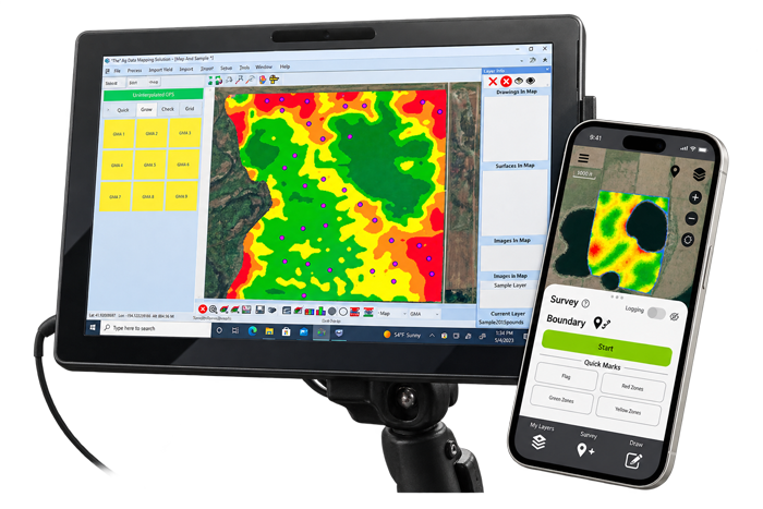
Desktop, In-Cab & Mobile Software | mapping services | Built & Supported by farmers for agronomists nationally | 35+ years in precision agriculture
Providing Innovative Technological Solutions for Agriculture’s Challenges
Your source for precision agriculture mapping and drainage software and services
GK Technology has spent more than 35 years building mapping and drainage software and mapping services for agriculture. Farmers, agronomists, consultants and contractors across the country use our solutions to map their fields, decided where to plant, how to move water, and so much more.
Your field data
Bring what you have, collect what you don't, or use GK's library. Then put it to work as maps, prescriptions, and drainage plans.
Bring what you have
- Elevation, imagery, yield, and soil
- From your RTK survey or LiDAR
No data? Collect it in the field
- Use a laptop or tablet in the cab
- Map boundaries and take GPS soil samples
Use GK's data library
- Satellite and aerial imagery (Sentinel, Landsat, NAIP)
- Elevation data (LiDAR) where available
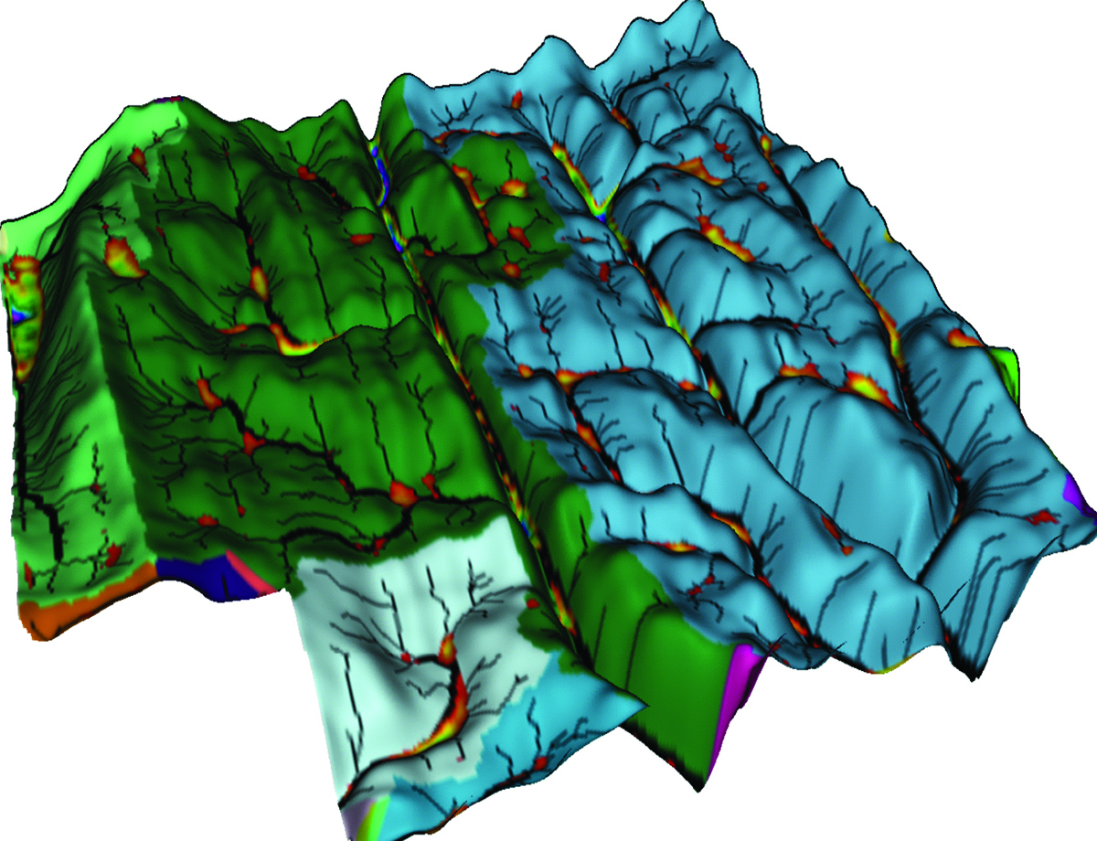
ADMS
- Variable rate for every acre
- Agronomy and drainage in one program
- Works with controllers you already run
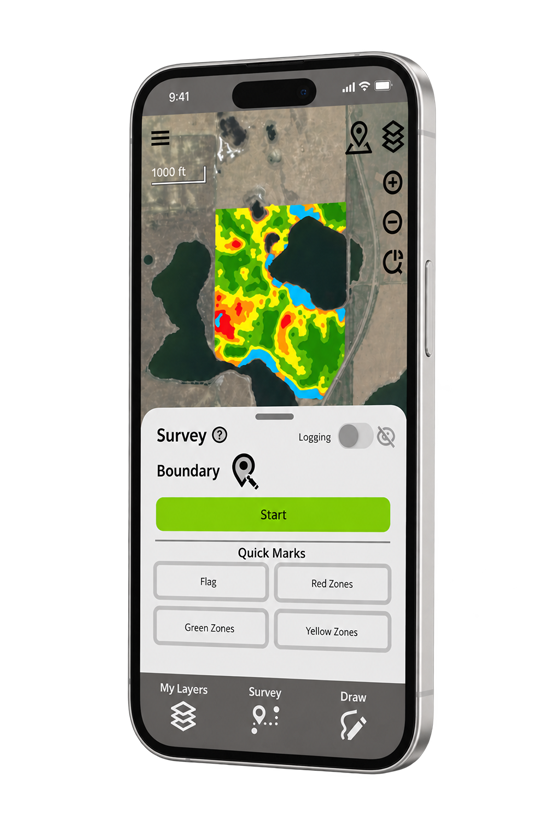
GK Field Mapper
- Measure acres and mark finds on the spot
- Works offline in remote areas
- iOS and Android, no account to start
Mapping Services
- Topography, zones, and tile plans
- Built by the team that writes the software
- Finished maps back, ready this season
One Platform, Only The Modules You Need
We've built THE Ag Data Mapping Solution - ADMS
ADMS is precision desktop and in-cab software for field mapping and drainage design. It turns the field data you already have, elevation, imagery, and yield, into variable rate prescriptions and drainage plans your equipment can run, so every acre gets the right rate and every field drains the way you want.
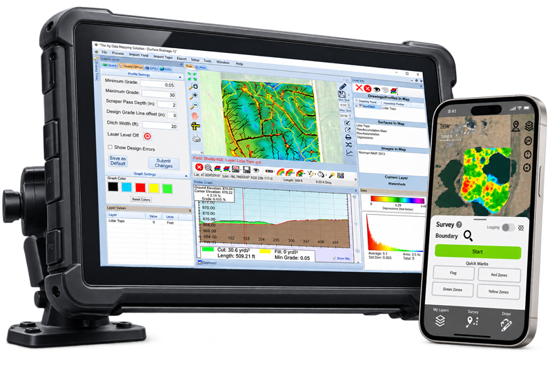
Your whole field, in one program.
Complete mapping, variable rate, and drainage design on your own machine. One elevation surface and one set of field data feed everything, from a prescription to a tile plan, so nothing is rebuilt twice.
Highly-accurate 2D/3D topography maps of your land for a comprehensive visual experience
Agronomy and drainage in one platform
Compatible with the rate controllers you already own
Ships with the background data: TIGER, NAIP, and soils
Runs on windows PC and can be used in-cab
Aplication maps from 5 to 200+ zones
Task-oriented modules
Start with the base. Add modules as you grow.
Every ADMS setup begins with the GPS Mapping base package, the foundation for collecting and working your field data. That is where everyone starts.
From there you tack on task-oriented modules as your operation needs them, so you only ever pay for and learn the tools you actually use.
GPS Mapping and Zone Soil Testing
The foundation every ADMS setup is built on.
- Turn a laptop or tablet into a field collector
- Draw boundaries, lines, and points
- GPS-guided soil sampling, ditching, and spraying
- Builds the zones every other module uses
Imagery
See fields from above and turn it into zones.
- Import your own satellite or aerial imagery
- Or pull GK's Landsat, Sentinel, and NAIP library
- Surface, filter, and build management zones
- Ready for soil sampling and variable rate
Topography, Drainage, Yield and Variable Rate
The workhorse for agronomy and water, one surface.
- Color relief, watersheds, hills, and depressions
- Plan ditching with slope, cut, and fill
- Clean yield and Veris data into zones
- Write maps from a few zones to 200+
Surface Shaping
Serious drainage design, past ditching and leveling.
- Design intentional water flow and direction
- Build walls, cut and fill hills, morph the surface
- Outputs a machine-ready prescription map
- Pairs with SD Surface machine control
Data package
ADMS Consultants Package
Unlocks GK's imagery library and adds confidence mapping, faster processing tools, consultant mapping services, and free admission to all training classes.
What is in the library
- Sentinel 10 meter satellite imagery
- Landsat 30 meter satellite imagery, 30+ years
- NAIP imagery for most US counties
- State and federal flown LiDAR, where available
What it lets you do
- Extract as many fields as you want from the library
- Drive 3D features and watershed and drainage work from imported LiDAR
- Build confidence, max production, and average production maps
- Attend every GK training class at no cost
How it works
One dataset, carried all the way to the field.
ADMS moves a single set of field data through four steps, and each module does one job along the way. Because every step runs on the same ground, agronomy and drainage never start from scratch.
Bring in your data
Start from whatever you already trust: RTK or LiDAR elevation, imagery, yield, Veris, and soil. Your laptop or tablet becomes the collector in the field.
ADMS builds the maps
One elevation surface becomes color relief, flow accumulations, watersheds, hills, and depressions. Imagery and yield are surfaced, filtered, and zoned.
Design the plan
Turn zones into variable rate prescriptions, and turn the surface into ditching, tile, and shaping plans, with slope, cut, and fill shown before a machine moves.
Send it to the equipment
Write application maps to the rate controllers you already own, and export guidance and backgrounds to SD Drain machine control for drainage.
Done For You Mapping Services
Would you rather hand off the acres?
Not everyone wants to run the software, and not every job needs it in-house.
GK's team or our mapping partners can professionally map the acres for you. Tell us the fields and we scope the work. We'll build you maps that will improve your yield.
Who GK maps for
Premium service
Confidence Mapping
Take the guesswork out of zone creation.
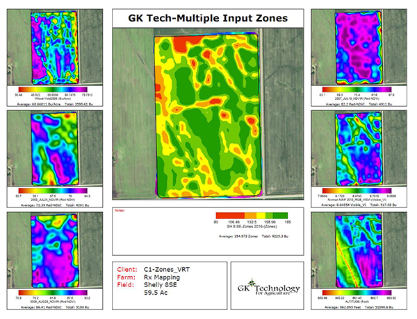
GK's own process merges 2 to 52 of your field maps into three stable maps. Instead of drawing zones off a single year, you see how ground really behaves over time, so your zone lines stop being a judgment call.
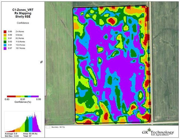
Confidence Map
Steady vs erratic ground, zone by zone
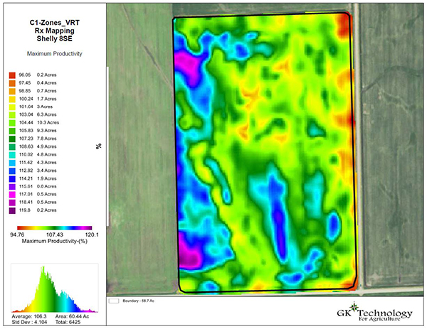
Yield Potential Map
The top end each area can reach, for yield goals
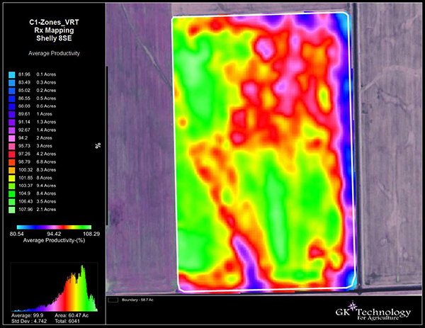
Average Production Map
Every layer blended into one, for management zones
Additional mapping services
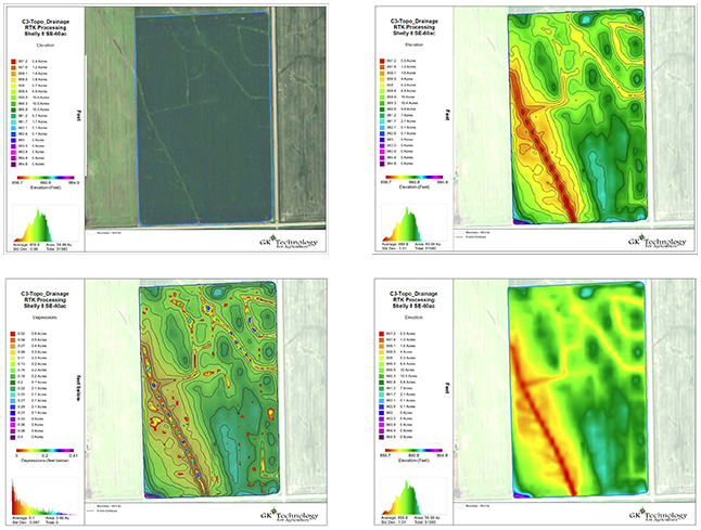
Topography Mapping
- 2D and 3D elevation and contours
- From your RTK survey or public LiDAR
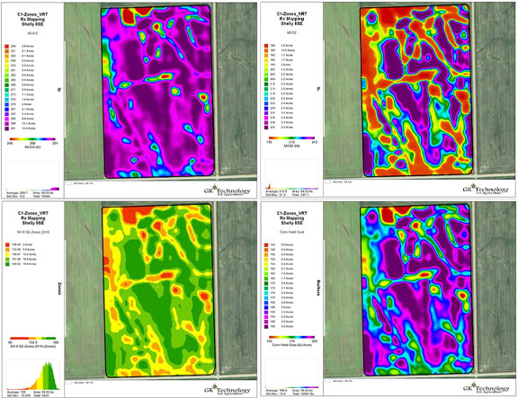
Variable Rate Imagery
- Management zones from your imagery
- Application maps for the equipment you run
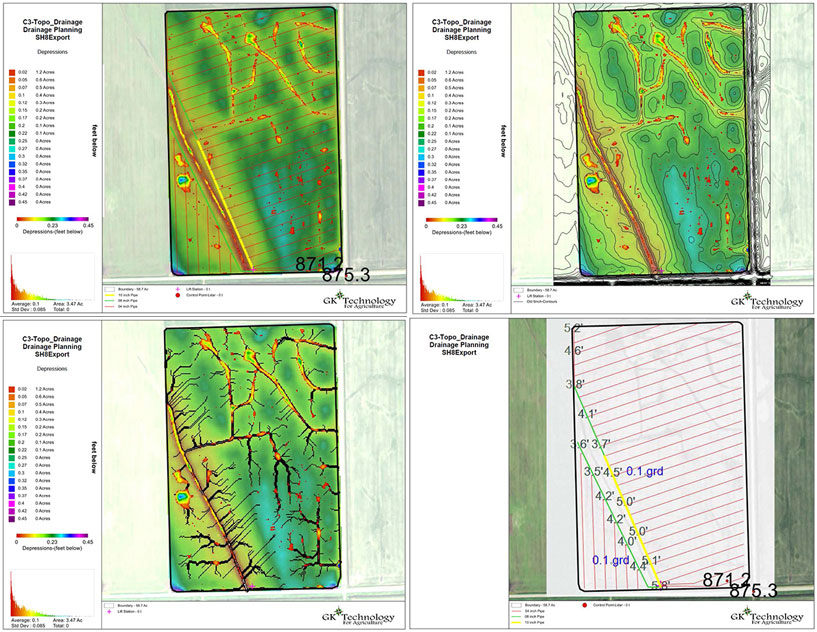
Tile Planning
- Grades, cut, and fill worked out
- Layouts your installer can put in the ground
Start Mapping Today For Free
Put the map in your pocket with
GK Field Mapper
GK Field Mapper is a mobile GIS data viewer and field mapping tool that works with or without a signal.
Create layers, surveys, and create maps right from your phone.
- Load Google, ESRI, and OpenStreetMap imagery
- Survey points, lines, polygons, and benchmarks
- Measure distances and acres accurately
- Log full GPS data for entire fields
- View shapefiles, KML, DXF, GPX, and CSV
- Use internal or external GPS over Bluetooth
- Real time weather on map objects
- Works offline in remote areas
Partners
The network behind the software.
GK works with resellers, machine-control and equipment partners, and universities across the Upper Midwest and the Canadian prairies.










Free Data
Looking for LiDAR or NAIP imagery, not software?
Plenty of people land here hunting for public elevation and imagery data for a specific state or county. We've spent years identifying and building a vast library of the best data links available publicly.
Our data guides walk through where each source lives, what it covers, and how to get it into a usable format. Our software transforms this data into profitable maps.
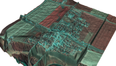
2008 NAIP photo draped over LIDAR of the City of Halstad, MN, on the Red River. The dikes and oxbows are clearly visible.
Common questions
What growers, consultants, and contractors ask most.
Straight answers about the software, the mapping services, where GK works, and how to get started.
What is Ag Data Mapping Solution (ADMS)?
ADMS is GK Technology's desktop mapping software for agriculture. It turns elevation, imagery, and yield data into variable rate prescriptions, topography and watershed maps, and drainage designs. It is built as task-focused modules, so you start with GPS Mapping and add only the tools your operation needs.
Where does GK Technology provide software and mapping services?
GK's software can be purchased and run anywhere in the United States and Canada. Hands-on mapping services and support are concentrated where GK is strongest: the Red River Valley, the broader Upper Midwest, the Corn Belt I-states of Iowa, Illinois, and Indiana, and the Pacific Northwest. GK is based in Halstad, Minnesota.
Does GK Technology do both agronomy and drainage?
Yes. Variable rate agronomy and drainage design run on the same field data inside ADMS, which is unusual, since most tools handle one side and leave the other to a separate program. For operations that work both crops and water, that integration is the main reason they choose GK.
What rate controllers and equipment does ADMS work with?
A wide range. ADMS includes Field Operations Data Drivers (FODD), GK's own drivers that write application maps for many of the rate controllers and displays on the market, including aftermarket units. Prescriptions go straight to the equipment you already own instead of forcing a new controller.
How is ADMS priced, and how do I buy it?
ADMS is sold as modules, so pricing depends on which base and add-ons fit your operation. You buy it through GK or an authorized reseller, and GK will help you assemble the right set of modules. Contact GK for current pricing.
Do I run the software myself, or can GK map my fields for me?
Either way. Many customers run ADMS themselves, while others send their fields to GK and get finished topography, imagery, confidence, or tile maps back. Some use the mapping services for a first season and run the software after that.
Is GK Field Mapper free?
Yes. The free version of GK Field Mapper includes imagery basemaps, surveying of points, lines, and polygons, distance and area measurement, GPS logging, offline use, and viewing of common data formats. Paid plans add full-format export, routing, and cloud sync with ADMS. It runs on iOS and Android.
Can I use public LiDAR instead of an RTK survey for topography?
In many areas, yes. GK builds topography from your own collected data, where an RTK quality signal is recommended, or from public LiDAR where coverage exists. Which one fits depends on your state, the age of the LiDAR flight, and how much relief the field has.
Where can I find LiDAR or NAIP imagery for my state or county?
GK's data guides point to where public elevation and imagery data lives for each state and county, what it covers, and how to get it into a usable format. ADMS then turns that raw data into topography, management zones, and drainage maps. Start in the Data Links section of the site.
What do I need to run ADMS?
ADMS is desktop software for Windows PC and can be used in-cab. It ships with background data including TIGER, NAIP, and soils, and your field data stays on your own computer.
What support and training does GK provide?
Support comes from the same team in Halstad, Minnesota, that writes the software, and a remote session can put a technician on your screen when a map is not behaving. GK also runs training classes, which are included at no cost with the Consultants Package.
How long has GK Technology been in precision agriculture?
More than 35 years. GK Technology is based in Halstad, Minnesota, in the Red River Valley, and has built precision ag mapping and drainage software and services throughout that time.
Contact
Get in touch with GK.
Tell us a little about your operation and what you are trying to solve. A real person in Halstad reads every message and follows up within a few hours.