

Every map in your pocket, online or off.
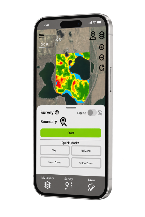
GK Field Mapper is the mobile GIS app for the field edge. Survey boundaries, measure acres, view your data on live imagery, and keep working where there is no signal.
Start on the free plan. Upgrade only when you need cloud sync and full exports.
Made for the field
Turn a walk across the field into data you can act on.
Whether you scout, sample, quote acres, or lay tile, GK Field Mapper puts a full GIS toolkit in your pocket. It is all in the free plan, works with no signal, and syncs home to Ag Data Mapping Solution (ADMS) when you are ready.
Mark what you find, right where you find it
Drop points, trace lines, and close boundaries as you walk, all georeferenced. Set benchmarks you can return to later.
Know your acres before you quote or apply
Measure distance and acreage on the spot, then style labels and colors so every feature reads at a glance.
See your data on the real ground
Load live imagery from Google, ESRI, or OpenStreetMap so your points and lines sit exactly where they belong.
Bring the office maps to the field
Open shapefiles, KML, DXF, DWG, GeoJSON, GPX, CSV, and georeferenced images, and edit their attributes in the cab.
See where the water goes before you dig
View elevation profiles for surveyed GPS logs and lines, so a drainage run or a field pass shows its rise and fall.
Keep the conditions with the record
Pull real-time weather onto map objects, so what it was doing is saved with the point, not in a separate app.
In the field
How a farmer turns a wet corner into a drainage plan.
Every spring, water stands in the same low spot. Here is the whole path from walking that corner to a finished tile plan, using GK Field Mapper and ADMS.
Pull up the field, signal or not
- Open your field on the map
- Turn on satellite view
- Start mapping with no signal
Walk the wet spot and trace it
- Walk the edge of the wet area
- Trace the boundary as you go
- Drop a pin where water stands
See what the low corner costs
- Tap the area you traced
- Read the acres on the spot
- See the ground you lose each spring
Find out where the water goes
- Walk the draw with GPS logging on
- Open the elevation profile
- Spot the low path before you dig
Hand it off to ADMS
- Save the field to the GK Cloud
- Open it in ADMS at the office
- Get back a tile plan with grade, cut, and fill
A tile plan on the acres you walked.
The fieldwork takes an afternoon. ADMS turns it into a plan your installer can put in the ground, so next spring that corner drains instead of drowning.
Watch GK Field Mapper in the field.
A quick look at surveying, measuring, and viewing data on imagery, from the map screen most people use every day.
Works with your other tools
Reads what you have. Writes what you need.
GK Field Mapper speaks the formats your other software already uses. Bring in data from GIS, CAD, a GPS unit, Google Earth, or a spreadsheet, work it in the field, then send it back out, or sync straight to ADMS through the GK Cloud.
GIS software
Trade field boundaries and zones with Esri ArcGIS and QGIS, the mapping systems most agronomists and offices run.
Google Earth & Maps
Open placemarks and areas from Google Earth, or hand your fields back for easy sharing and viewing.
CAD & survey
Exchange lines and drawings with AutoCAD and Civil 3D, the way surveyors and tile designers deliver work.
GPS units
Move tracks and waypoints to and from Garmin and other handheld GPS receivers.
Spreadsheets & sampling
Pull soil sample points and lab results out of Excel, and write tables back out for records.
Imagery & scans
Drop georeferenced photos and scanned maps underneath your data as a backdrop in the field.
Viewing works on every plan. Exporting is included on paid plans, and the free plan exports to GeoJSON, so your fieldwork always has a way out.
Part of the GK system
The field end of Ag Data Mapping Solution.
GK Field Mapper is where data comes in and goes out. On a paid plan, the GK Cloud moves files between the app and ADMS, GK's desktop mapping software, so what you survey feeds the maps you build.
GK Field Mapper
Survey boundaries, points, and GPS logs in the field, on your phone or tablet.
ADMS on the desktop
Turn that field data into zones, prescriptions, topography, and drainage plans back at the office.
Choose your plan
Free to start. Upgrade for cloud and full exports.
Get basic maps for free, or unlock the GK Cloud and every export format with a paid plan. Prices in USD.
Everything you need to survey, measure, and view in the field.
- Survey points, lines, polygons
- Measure distance and area
- Web imagery basemaps
- View vector data and images
- Elevation profiles
- Full offline use
- Export to GeoJSON
Adds full exports, routing, and cloud sync with ADMS.
- Everything in Free
- Export to all formats
- Generate routes
- GK Cloud access
- 100 MB cloud storage
More cloud storage and sharing for heavier field use.
- Everything in Standard
- 1 GB cloud storage
- Send data to other GK Cloud users
Team storage and multi-user support for larger operations.
- Everything in Professional
- 10 GB cloud storage
- Support for multiple users
| Feature | Free | Standard | Professional | Enterprise |
|---|---|---|---|---|
| Web imagery from Google, ESRI, OpenStreetMap | ✓ | ✓ | ✓ | ✓ |
| Survey points, continuous points, lines, polygons, benchmarks | ✓ | ✓ | ✓ | ✓ |
| Log full GPS data for entire fields | ✓ | ✓ | ✓ | ✓ |
| Draw georeferenced lines, points, and polygons | ✓ | ✓ | ✓ | ✓ |
| Measure distances and areas | ✓ | ✓ | ✓ | ✓ |
| Style labels and colors | ✓ | ✓ | ✓ | ✓ |
| Real-time weather for map objects | ✓ | ✓ | ✓ | ✓ |
| Internal or external GPS via Bluetooth or WiFi | ✓ | ✓ | ✓ | ✓ |
| Open georeferenced images (.grd, .bmp, .jpg) | ✓ | ✓ | ✓ | ✓ |
| View vector data (.shp, .kml, .dxf, .dwg, GeoJSON, GPX, CSV, and more) | ✓ | ✓ | ✓ | ✓ |
| Edit and view attribute fields | ✓ | ✓ | ✓ | ✓ |
| Elevation profiles for GPS logs and lines | ✓ | ✓ | ✓ | ✓ |
| Offline functionality in remote areas | ✓ | ✓ | ✓ | ✓ |
| Export to GeoJSON | ✓ | ✓ | ✓ | ✓ |
| Export to all formats (.shp, .kml, .dxf, .dwg, GPX, CSV, and more) | ✓ | ✓ | ✓ | |
| Generate routes to an address or feature | ✓ | ✓ | ✓ | |
| GK Cloud access to move files to ADMS | ✓ | ✓ | ✓ | |
| GK Cloud storage | 100 MB | 1 GB | 10 GB | |
| Send data to other GK Cloud users | ✓In development | ✓In development | ||
| Support for multiple users | ✓In development |
Common questions
Before you download.
Is GK Field Mapper really free?
Yes. The free plan includes surveying, measuring, web imagery basemaps, GPS logging, offline use, viewing of vector data and georeferenced images, elevation profiles, and export to GeoJSON. Paid plans add full-format export, routing, and GK Cloud sync with ADMS.
Does it work without cell service?
Yes. Surveying, measuring, and viewing saved data all work offline, which is the point in remote fields. When you are back in range, a paid plan can sync your files through the GK Cloud.
What phones and GPS receivers does it support?
GK Field Mapper runs on iOS and Android. It uses the device's built-in GPS, or you can connect an external receiver over Bluetooth or WiFi for higher accuracy.
What file formats can it open and export?
It views shapefiles, KML, KMZ, GeoJSON, GeoParquet, DXF, DWG, GPX, CSV, and georeferenced images (.grd, .bmp, .jpg) on any plan. Free plans export to GeoJSON, and paid plans export to all of those vector formats.
How does it work with ADMS?
On a paid plan, the GK Cloud moves files between GK Field Mapper and Ag Data Mapping Solution, GK's desktop software. Field data you collect flows into ADMS for zone creation, prescriptions, topography, and drainage design.
Contact
Get in touch with GK.
Tell us a little about your operation and what you are trying to solve. A real person in Halstad reads every message and follows up within a few hours.